


Satellite Image Fusion using Matlab
₹3,000.00
Huge Price Drop : 50% Discount
Source Code + Demo Video
8 in stock
Description
ABSTRACT
Unlike multispectral (MSI) and panchromatic (PAN) images, generally the spatial resolution of hyperspectral images(HSI) is limited, due to sensor limitations. In many applications,HSI with a high spectral as well as spatial resolution are required.In this paper, a new method for spatial resolution enhancementof a HSI using spectral unmixing and sparse coding (SUSC) is introduced. The proposed method fuses high spectral resolution features from the HSI with high spatial resolution features from anMSI of the same scene. Endmembers are extracted from the HIS by spectral unmixing, and the exact location of the endmembersis obtained from the MSI. This fusion process by using spectral unmixing is formulated as an ill-posed inverse problem whichrequires a regularization term in order to convert it into a wellposedinverse problem. As a regularizer, we employ sparse coding(SC), for which a dictionary is constructed using high spatial resolution MSI or PAN images from unrelated scenes. The proposed algorithm is applied to real Hyperion and ROSIS datasets. Compared with other state-of-the-art algorithms based on pan sharpening, spectral unmixing, and SC methods, the proposed method is shown to significantly increase the spatial resolution while preserving the spectral content of the HSI.
INTRODUCTION
Image fusion is a process, which creates a new image representing combined information composed from two or more source images. Generally, one aims to preserve as much source information as possible in the fused image with the expectation that performance with the fused image will be better than, or at least as good as, performance with the source images. Image fusion is only an introductory stage to another task, e.g. human monitoring and classification. Therefore, the performance of the fusion algorithm must be measured in terms of improvement or image quality. Several authors describe different spatial and spectral quality analysis techniques of the fused images. Some of them enable subjective, the others objective, numerical definition of spatial or spectral quality of the fused data . The evaluation of the spatial quality of the pan sharpened images is equally important since the goal is to retain the high spatial resolution of the PAN image. A survey of the pan sharpening literature revealed there were very few papers that evaluated the spatial quality of the pan-sharpened imagery . Consequently, there are very few spatial quality metrics found in the literatures. However, the jury is still out on the benefits of a fused image compared to its original images. There is also a lack of measures for assessing the objective quality of the spatial resolution of the fusion methods. Therefore, an objective quality of the spatial resolution assessment for fusion images is required. Therefore, this study presented a new approach to assess the spatial quality of a fused image based on High pass Division Index (HPDI). In addition, many spectral quality metrics, to compare the properties of fused images and their ability to preserve the similarity with respect to the original MS image while incorporating the spatial resolution of the PAN
EXISTING SYSTEM
Principal component analysis (PCA) methods have been a popular choice for spatial and spectral transformations, respectively. Current PCA-based pan-sharpening methods make an assumption that the first principal component (PC) of high variance is an ideal choice for replacing or injecting it with high spatial details from the high-resolution histogram-matched panchromatic (PAN) image. This paper presents a combined adaptive PCA-contourlet approach for pan-sharpening and clustering(K-means). The efficiency of the presented method is tested by performing pan-sharpening of the high-resolution (IKONOS and QuickBird) and the medium-resolution (Landsat-7 Enhanced Thematic Mapper Plus) datasets. The evaluation of the pan-sharpened images using global validation indexes reveal that the adaptive PCA approach helps reducing the spectral distortion, and its merger with contourlets provides better fusion results
DRAWBACKS
- Contrast information loss due to averaging method
- Maximization method sensitive to sensor noise and high spatial distortion
- K means – It is not suitable for all lighting condition of images
- Difficult to measure the cluster quality
PROPOSED SYSTEM
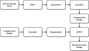
The accuracy of the DSMs generated from stereo images largely depends on the radiometric data quality, the GSD of the data, the convergence angle of the stereo data, and the amount of available stereo pairs. In most cases, the DSM exhibits 3-D information but also different kinds of inaccuracies . The aim of this paper is to generate a high quality change map by fusing the building change indicators and no-building change indicators from DSMs and the original images. Therefore, as shown in Fig. 1, we divide the proposed method into two parts: the fusion of pixel-based building change indicators and refinement of building change result using no-building change indicator. Finally, an object-based building extraction based on shape features is employed.
- Dual Level Wavelet and Log Ration Transform
- Detection of Back scattering Changes at Building Scale
- Building Detection using NN classifier
BLOCK DIAGRAM

ADVANTAGES
- Accurate detection of foreground changes by fusion
- Less sensitive to noises
APPLICATIONS
- Earth land changes detection in Satellite field
- Medical field
SOFWARE REQUIREMENT
- MATLAB 7.14 and above versions
FUTURE ENHANCMENT
As future work, an investigation of the DSM quality in various situations will be performed and might be added to our fusion model. Moreover, in this research, only pixel-based features are employed; more texture features will also be tested in future follow up work if they can give indication for building change or no building change. For the object-based building change map refinement procedure, more and also 3-D shape features could be used to improve the overall change detection result.
REFERENCES
[1] H. Hirschmüller, “Stereo processing by semiglobal matching and mutual information,” IEEE Trans. Pattern Anal. Mach. Intell., vol. 30, no. 2, pp. 1–14, Feb. 2008.
[2] P. d’Angelo, M. Lehner, and T. Krauss, “Towards automated DEM generation from high resolution stereo satellite images,” in Proc. ISPRS Congr., Beijing, China, 2008, vol. 37, pp. 1137–1342, Part B4.
[3] P. d’Angelo and P. Reinartz, “Semiglobal matching results on the ISPRS stereo matching benchmark,” in Proc. ISPRS Workshop, Hannover, Germany, Jun. 2011, vol. 38-4/W19, pp. 79–84.
[4] A. Singh, “Digital change detection techniques using remotely-sensed data,” Int. J. Remote Sens., vol. 10, no. 6, pp. 989–1003, 1989.
[5] D. Lu, P. Mausel, E. Brondizio, and E. Moran, “Change detection techniques,” Int. J. Remote Sens., vol. 25, no. 12, pp. 2365–2407, Jun. 2004.
[6] D. Koc San and M. Turker, “Automatic building detection and delineation from high resolution space images using model based approach,” in Proc. ISPRS Working Groups I/5-I/6I Workshop (Topograph. Mapping Space), Ankara, Turkey, Feb. 2006, vol. 36-1-W41, pp. 1–6.
[7] Z. Liu, P. Gong, P. Shi, H. Chen, L. Zhu, and T. Sasagawa, “Automated building change detection using UltraCamD images and existing CAD data,” Int. J. Remote Sens., vol. 31, no. 6, pp. 1505–1517, Mar. 2010.
[8] T. Knudsen and B. P. Olsen, “Automatic change detection for updates of digital map database,” Photogramm. Eng. Remote Sens., vol. 69, no. 11, pp. 1289–1296, Nov. 2003.
[9] B. P. Olsen, “Automatic change detection for validation of digital map databases,” in Proc. ISPRS Congr., Istanbul, Turkey, 2004, vol. 34, pp. 569–574, Part B2.
[10] F. Rottensteiner, J. Trinder, S. Clode, and K. Kubik, “Using the Dempster- Shafer method for the fusion of LIDAR data and multispectral images for ‘building detection,” Inf. Fusion, vol. 6, no. 4, pp. 283–300, 2005
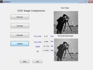
DEMO VIDEO
Additional information
| Weight | 0.000000 kg |
|---|


Reviews
There are no reviews yet.