Matlab Code for Satellite Multispectral Image Enhancement
₹3,000.00
Huge Price Drop : 50% Discount
Source Code + Demo Video
100 in stock
Description
ABSTRACT
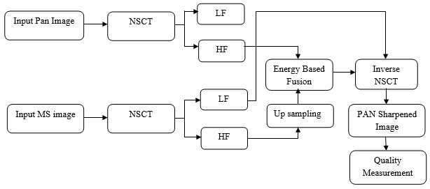
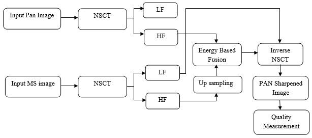
The project presents that pansharpening based Non-subsampled contourlet transformation for satellite panchromatic and multi spectral images. It involves two different approaches that are, NSCT with different levels of decomposition and NSCT with up sampling based pixel level fusion. NSCT is very efficient in representing the directional information and capturing intrinsic geometrical structures of the objects. It has characteristics of high resolution, shift-invariance, and high directionality. An integration of high spatial resolution extracted from PAN images into the high spectral resolution of MS images generates both high spatial and spectral resolution pan sharpened image. Here, a given number of decomposition levels are used for multispectral images while a higher number of decomposition levels are used for Pan Images relatively to the ratio of the Pan Pixel size to the MS pixel size. This preserves both spectral and spatial qualities while decreasing computation time. By applying upsampling after NSCT, structures and detail information of the MS images are more likely to be preserved. Hence, pan-sharpening is done by fusing it with detail information provided by the Pan image at the same fine level. The system simulated result shows that used method provides better resolution in these images rather than prior approaches and it also measured the performance parameters such as correlation, PSNR, SSIM and standard deviation.
EXISTING SYSTEM
- IHS Transformation
- Principal Component Analysis
- Discrete wavelet and Curvelet transformations
DRAWBACKS
- More Color and spectral distortion
- Poor discriminatory power
- Limited representation of contour edges due to sub sampling.
PROPOSED METHOD
The Fusion of panchromatic and multispectral images for PAN sharpening based on,
- Non subsampled contourlet transform and Pixel level Fusion
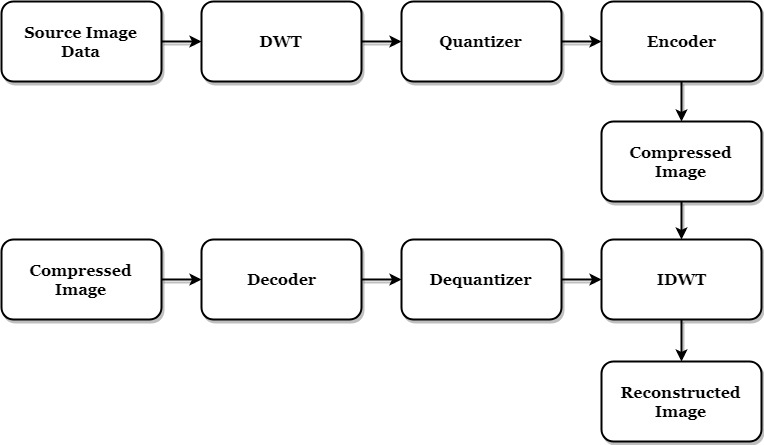
BLOCK DIAGRAM
METHODOLOGIES
- Different Level NSCT
- Energy Measurement
- Pixel Level Fusion
- Parametric Evaluation
ADVANTAGES
- Minimal spectral distortion
- Better edge representation due to shift invariant property
- It provides high spatial and spectral resolution MS images
APPLICATION
- Satellite Imaging
- Human Visual System
SOFTWARE REQUIREMENTS
- MATLAB 7.5 and above versions
RESULT
FUTURE ENHANCEMENT
- This resolution enhancement can further improves with Lanczos based upsampling and Gabor filtering for texture characterization.
- Upsampling reduces the distortion of detailed information and Gabor provides detail, structure components at different orientations
REFERENCES
[1] V. P. Shah, N. H. Younan, and R. L. King, “An efficient pan-sharpening method via a combined adaptive PCA approach and contourlets,” IEEE Trans. Geosci. Remote Sens., vol. 46, no. 5, pp. 1323–1335, May 2008.
[2] T. M. Tu, S. C. Su, H. C. Shyu, and P. S. Huang, “A new look at IHS-like image fusion methods,” Inf. Fusion, vol. 2, no. 3, pp. 177–186, Sep. 2001.
[3] M. Chikr El-Mezouar, N. Taleb, K. Kpalma, and J. Ronsin, “A new intensity-hue-saturation fusion technique imagery with color distortion reduction for IKONOS,” ICGST Int. GVIP J., vol. 9, no. 4, pp. 53–60, 2009.
[4] I. Amro, J. Mateos, M. Vega, R. Molina, and A. K. Katsaggelos, “A survey of classical methods and new trends in pansharpening of multispectral images,” EURASIPJ.Adv.Signal Process., vol.2011, no. 79, pp.1–22, 2011.
[5] M. N. Do and M. Vetterli, “The contourlet transform: An efficient directional multi resolution image representation,” IEEE Trans. Image Process., vol. 14, no. 12, pp. 2091–2106, Dec. 2005.
[6] T. Xu and Y. Fang, “Remote sensing image interpolation via the non subsampled contourlet transform,” in Proc. Int. Conf. Image Anal Signal Process., Zhejiang, China, 2010, pp. 695–698.
[10] K. Amolins, Y. Zhang, and P. Dare, “Wavelet based image fusion techniques- An introduction, review and comparison”, ISPRS, J. Photogramm Remote Sens., vol. 62, no. 4, pp. 249–263, Sep. 2007.



Reviews
There are no reviews yet.